Research / Other Projects / Sustainable Water Supply and Quality

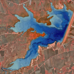
Water Resource Assessment

Land-use changes and urbanization expose upper layer soils to wind and water erosion delivering sediment to lakes and reservoirs.  Sedimentation of water resources is a natural process, however not always beneficial.  In order to effectively manage aquatic resources, it is critical to know the exact acreage, depths, and volume of a water resource through regular assessments.  Measurements provide valuable information to:

  • Calculate current storage capacities and projected longevity of water resources;
  • Conduct volumetric analysis of sedimentation rates and deposition; and
  • Determine long-term effectiveness of erosion-reducing conservation practices implemented.

Bathymetric Mapping

Bathymetric mapping combines several technologies including: differential global positioning system (DGPS), acoustic depth sounder, and geographic information system (GIS) software.   The information can be used to calculate water availability and track sediment deposition.

Sub-Bottom Profiling and Sediment Surveys

Sub-bottom profiling surveys use low frequency acoustics to determine the depth of water from water surface to sediment layer. Core samples are used to verify remotely sensed sediment accumulation data and can be used to determine historical erosion rates.

Impacts

Water use and availability, flood control, fish and wildlife habitat, and general recreation can be affected by sedimentation of water resources.  Both sub-bottom and bathymetric assessments offer valuable information which can be supplemented with prior or future surveys to determine whether sediment accumulation is increasing or decreasing.  The findings of the surveys may be used by resource managers as a decision support tool to determine potential impacts on our water resources from existing or planned erosion mitigating strategies.

Partners

Texas State Soil and Water Board

River Authorities

Environmental Protection Agency

Water Control and Irrigation Districts

Private Land Owners

Department of Defense

Tribal Nations

Natural Resources Conservation Service

Agricultural Research Service