Journey comes to an end in Temple after 111 years
November 2010
by Patricia Benoit
Telegram Staff Writer
When it comes to protecting Texas terra firma, the “last acre” is only the beginning.
About 200 dignitaries from Washington, D.C., and throughout Texas converged Wednesday on a patch behind the USDA-ARS Grassland, Soil and Water Research Laboratory to mark the final soil mapping of the state’s 172 million acres.
They also dedicated a granite monolith recognizing the state, federal and local entities that united to finish the job over the past 111 years.
No one was more proud of the day’s activities than retired soil scientist Wilson Moon, 99. He started working on soil surveys in 1935 as part of the former Soil Erosion Service. He and his wife, Dorothy, were honored guests.
When Moon started working, he used rudimentary tools such as shovels and plane tables. The work was speeded up in recent decades by advanced technology from sophisticated interrelated software, satellite imagery and geographic information systems.
The Texas maps are part of a program to analyze every acre in the nation. The program is about 95 percent complete. California, some Rocky Mountain states, Hawaii and Alaska have yet to be completed.
Although the actual last acre is in Hudspeth County, this local plot of Bell County Blackland was designated as the symbolic end to the project that began in 1899. Temple is the state headquarters for the Natural Resources Conservation Service, a branch of the U.S. Department of Agriculture.
The celebration coincided with the 75th anniversary of NRCS’s founding in 1935.
The 12 speakers sharing keynoting honors reiterated the same theme: The mapping may be over, but the real work of conserving precious soil and water resources has only begun.
“Soil is the ‘golden goose’ for our country,” said Salvador Salinas, NRCS acting state conservationist. Our lives depend on soil … We’re not celebrating the last soil survey; we’re celebrating our future.”
The speakers emphasized that soil and water are the basic building blocks of industry, quality of life and human survival. Understanding and conserving natural resources are essential. The nation’s security, industry and economic stability depend on that.
Agriculture is “the only essential industry. We couldn’t do other things we do without it,” added Dr. Craig Nessler, director of Texas AgriLife Research.
Seconding him was Dr. Edward Smith, director of the Texas AgriLife Extension Service.
“Every bit of research is based on these soil surveys,” he said. “Everything depends on it – from community planning to agriculture. Back in the 1970s, we kept those books on our desks at all times. We called it ‘the bible.’ They were essential.”
Now that all the Texas survey has been loaded onto the Internet in a versatile, multi-dimensional format, the thick books are passé. Anyone in the world can pinpoint soil types in any plot of land in the state, Smith said.
Micheal Golden, national soil survey director for NRCS in Washington, outlined the next steps as mandated by Congress to the secretary of agriculture: keep the soil surveys relevant and current; make sure the information is useful and available to everyone; and promote it.
Golden was a former Texas state soil scientist, based in Temple, who worked on the state mapping for many years before moving to the national post.
The group reassembled at a nearby site to shovel the last bit of dirt into a test hole. Dignitaries used chrome-plated, engraved shovels, called “sharp-shooters,” for the ceremonial dig.
Afterward, the public was invited to view various research projects at the Grassland lab, NRCS and Texas AgriLife Research, Blackland Research and Extension Center. The displays emphasized the cooperation of state, federal and local entities to finish the massive project.
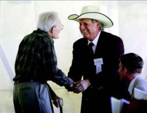
Jose Dodier, right, chairman of the Texas State Soil and Water Conservation Board, shakes hands with Wilson Moon, during the celebration to commemorate the completion of soil mapping on 172 million acres of Texas. The project is part of a national survey that began in 1899. Moon, 99, started with NRCS in 1934 before it became an official agency in 1935. –Photo by Rusty Schramm/Telegram
Texas’ soil survey program is led by the NRCS, with other USDA agencies, Texas AgriLife Extension and Research, various Texas universities, the Texas State Soil and Water Conservation Board and local soil and water conservation districts providing funding, personnel, soil analysis and research.
“The soil survey of Texas is a perfect example of how much more can be accomplished with a cooperative effort,” said Dennis Williamson, Texas state soil scientist with NRCS. “Without the superb cooperation of local, state and federal entities in Texas, our initial soil survey would be a long way from completion.”
Williamson said work will continue, using modern technology, to refine Texas’ soil surveys and to provide more assistance to landowners and natural resource agencies so that they can better manage land under their care.
–Reprinted with permission of Temple Daily Telegram