Granger Lake losing capacity to sedimentation
July 2010
State agencies are studying the lake, trying to protect Williamson County’s at-risk supply of drinking water.
By Fred Afflerbach – Telegram Staff Writer
GRANGER LAKE – When thunderstorms wake up those sleepy tributaries that fill Granger Lake they bring more than water. They bring mud.
Thirty miles south of Temple, this lake has grown significantly more shallow since it filled three decades ago. Compared to topographical maps taken in 1980 when the lake first started catching water, the most recent surveys show sediment was filling the lake bottom at a disturbing rate for 15 years, but later tapered off.
Although the rate of sedimentation has slowed, losing capacity means less drinking water for a growing and thirsty Williamson County.
According to the Texas State Soil and Water Conservation Board, Granger Lake today supplies drinking water for 20,000 Williamson County residents. In the next five to 10 years the public drinking water demands on the lake are expected to exceed 100,000 residents.
With more people in the next decade expected to rely on a shrinking lake, two state agencies – the Texas State Soil and Water Conservation Board and the Brazos River Authority – have teamed up to study where the sediment is coming from, how fast the lake is filling in and how to slow it down.
Determining the rate of sedimentation is the job of Jason McAlister, a researcher at the Blackland Research Center in Temple. McAlister is mapping the lake floor using a dual-frequency sonar – a fancy fish finder as McAlister calls it. Comparing the lake bottom in 2010 to a similar survey he performed in 2007 should help scientists understand if the changes in nearby agricultural practices have reduced the rate of sedimentation.
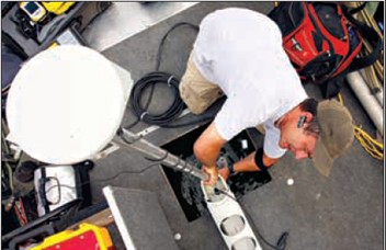
Jason McAlister of the Blackland Research Center sets up his global positioning satelite antenna on a pontoon boat at Granger lake last week. McAlister is mapping the sedimentation history of the lake floor.
“If we can look at that and say it filled in this much over a three-year period, then we can figure out an annual amount of deposition,” McAlister said. “Now if that is less or more than what they had previously calculated up to (the year) 2000, what they thought was the sedimentation rate, then you either have success or maybe you need to have some more conservation.”
Those conservation practices include farmers building terraces to reduce runoff and planting grass in waterways to mitigate runoff and reduce erosion. Called a water quality management plan, landowners and others have already implemented these methods on almost 15,000 acres in the Granger Lake watershed.
Mapping the lake bottom would also reveal which tributaries are carrying the most sediment, a good starting point to learn where the soil is coming from.
Granger Lake sedimentation is a concern to the Brazos River Authority because it is the state agency responsible for selling water to cities and utilities across a large swath of Texas.
Granger Lake Facts
- Dam at Granger Lake finished in 1980
- Estimated capacity in acre-feet. An acre-foot is the amount of waters it takes to cover ont acre one-foot deep.
- 1980—65,510
- 1995—54,280
- 2002—52,961
- 2060—22,597*
- If current rates of sedimentation continue, the lake would yield half as much water in 2060 as it did in 2000.
- *Estimated at current sedimentation rates sources: Texas state soil and Water Conservation Board, the Brazos River Authority & the Texas Water Development Board
“We’re supposed to ensure areas have adequate water supplies. If you start losing that much acreage, that much water from an important reservoir, in one of the highest growth areas in the state, then it raises eyebrows,” said Jay Bragg, Authority spokesman.
Agriculture producers aren’t the only group suspected of contributing to the erosion that causes sedimentation.