Riesel: A Local Treasure
May 2009
By Daren Harmel
USDA-ARS ENGINEER
Did you know that there’s a world-famous outdoor research facility right here in central Texas? It’s located about 2-1/2 miles east of Riesel, and while it’s officially called the Agricultural Research Service (ARS) Grassland, Soil and Water Research Laboratory, it’s commonly known as the Riesel Watersheds. The facility was established in 1937 as the Blacklands Experimental Watershed and is operated by ARS—the chief scientific research agency of the U.S. Department of Agriculture—in cooperation with Texas AgriLIFE Research.

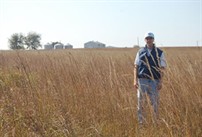
Engineer and site manager Daren Harmel in a native hay field at the USDA-ARS Riesel Watersheds.
The USDA-ARS Riesel Watersheds have provided valuable information to the water resource community for more than 70 years, making it one of the longest continuously monitored hydrologic research sites in the country. Long-term data sets are very rare, thus the 70 year data record from Riesel is extremely valuable for management of water supply, water quality, and flood impacts and for optimal design of culverts, bridges, detention basins and reservoirs. The information produced at Riesel is continually used by university, federal and state agency, and private consulting firms in hydraulic design, flood analysis, and infrastructure planning.
Currently, 13 water monitoring stations and 15 rain gauges are in operation to measure rainfall, runoff, and water quality on native prairie, improved pasture, and cultivated cropland. In addition to the active “edge- of-field” runoff sites, several larger stations located on Brushy Creek were monitored in the past.

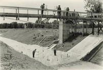
Streamflow measurements at a Brushy Creek sampling station in the late 1930’s. This station was located on private land downstream of the federally-owned smaller watersheds.
Visitors from across the United States and around the world come to Riesel to see the research site. In the last few years, we’ve given tours to scientists from Australia, Brazil, Canada, China, Germany, India, Pakistan and the United Kingdom, as well as professors and students from several universities, including Purdue, Arkansas, Georgia, Iowa State, Texas A&M, North Texas, Baylor, Louisiana State, and UT-San Antonio.
Baylor University Geology Department professor Peter Allen says his department uses the Riesel Watersheds for senior and graduate classes in hydrology “because Riesel is an excellent example of a world-class hydrologic field lab with examples of instrumentation from weather stations to weirs.”
The Riesel Watersheds facility is an excellent site for visitors to learn about state-of-the-art hydrologic and water quality instrumentation. That’s because very few sites have the type and amount of instrumentation we have to measure rainfall, runoff, and water quality from small agricultural watersheds. Visitors also come to site the see the Texas State Soil, which is Houston Black Clay. This soil is infamous for its shrinking and swelling, which causes considerable soil movement and damage to building and road foundations.
Another valuable feature at the Riesel Watersheds is a remnant (native) prairie site, which provides a valuable baseline (natural background) view of water quality in the Texas Blackland Prairie.
The site is managed as a typical Central Texas farm and ranch operation and is designed to provide field-scale, real-world information, which is a real plus for Riesel. In a recently published a paper on the history of the Riesel Watersheds, I noted that in the mid-1930s USDA realized the importance of understanding hydrologic processes on agricultural fields and watersheds and established three experimental watersheds. Of the three, the Riesel Watersheds and the North Appalachian Experimental Watershed near Coshocton, Ohio, are still operating.
Because water supply shortage, flood occurrence, and water quality degradation will increasingly affect the environment and future generations, watershed-based studies continue to be needed to solve these problems. With the Riesel Watersheds and ARS scientific expertise, we are here ready and willing to attack these new challenging questions and develop effective, economical solutions.
If you have questions or would like a tour of the site, please contact me at 254-770-6521 (daren.harmel@ars.usda.gov).
