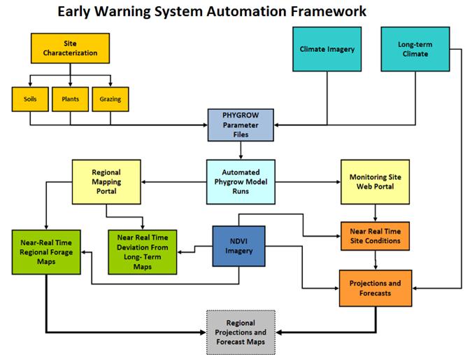
Models / PHYGROW: Grazing and Range Land Assessment
PHYGROW (Phytomass Growth Model) models above-ground herb and shrub growth, forage consumption, and hydrologic processes. It provides near real-time assessment of current and future forage conditions. PHYGROW is capable of modeling growth dynamics of many plant species competing for limited resources while modeling grazing by herbivores in competition for forage resources. It is a tool to determine how variations in landscapes, animal populations (composition, demand, and timing) and weather impact carrying capacity, hydrology, and stability of forage production. It is used to analyze variation in stocking decisions across representative landscapes in a region to determine impact of weather variation on stocking rates of mixed animal populations.
Capabilities
PHYGROW functions on a daily time step and is capable of simulating growth of multiple species of plants subject to selective grazing by multiple animals on a soil with multiple layers for indefinite periods of time. The model is designed to be integrated with a wide variety of weather databases, vegetation databases, and stocking rule databases and provides output for a wide variety of data sources and formats.
PHYGROW output can be integrated with the fire behavior model, PHYRESIM, to provide a continuously updated fire risk map for an area. Changing weather conditions and fluctuating plant communities create dynamic 30-minute burn areas, flame length, spread rate, and fuel moisture outputs. This data can be used to select areas beforehand with adequate fuel-load and appropriate weather conditions for a prescribed burn, as well as, determine wildfire risk conditions.
Impacts
- Provides early warning for drought or catastrophic winter conditions to reduce the risk of livestock mortality;
- Protects the ecological stability of rangeland resources;
- Improves animal nutrition;
- Helps herders and government officials organize themselves to better cope with risk and improve rangeland management; and
- Assesses fire conditions for any point to assist controlled burn crews, fire fighters, and other groups associated with fire management.
Utilization of PHYGROW:
US Forest Service Burning Risk Advisory Support System (BRASS)
- The system provides continuous means for forest and grassland managers to assess vegetation and weather to support decisions related to prescribed burning and/or the risk of wildfire.
Burning Risk Advisory Support System for the US Forest Service
- The objective of the vegetation and fire monitoring system is to inventory, monitor, evaluate, and integrate land condition trends and capabilities with US Forest Service requirements to enhance, improve, repair, and sustain public land management.
Forage Risk Assessment Management System (FRAMS)
- The system offers the means to monitor and assess the performance of free-grazing animals, the forage conditions in response to site-specific weather, and the potential least-cost feeding or de-stocking decisions relative to market and weather risk.
Livestock Early Warning System (LEWS)
- The model outputs data to produce continuous vegetation production and maps for the countries of Kenya, Ethiopia, Uganda, Tanzania, Southern Sudan, Dijoubtii, northern Somalia and Mongolia. The model combined with satellite imagery monitors and forecasts livestock forage conditions so that pastoralists and other decision makers have the needed information for timely decision making in the face of drought as well as help visualize the impact of their decisions.
- Projects: